Towards the North -East part of India lies the Seven states which have been a part of India after the Independence of India from the British Rule. Also known as the Seven Sister states (Excluding Sikkim), the places here have been a home to India’s largest Biodiversity regions with more than 10 national parks in the region, North – East India does given plenty of surprises with a wide range of flora and fauna available here.
Home to atleast 300 species of different kinds of Birds and variants of different species of plants, I don’t think none of the Indian states of the northern region would have this much number of birds and flowers in it.
One of the special kind is that not only the bio-diversity of the region lies because of the flora and fauna, but also through the culture, food and living styles that one experiences. Go through our article and we will show you the wonders of each state.
(P.S – Going to the regions of North-East India, one needs to get special permit from the government. These permits can be availed from the offices registered in New Delhi, Kolkata & Guwahati irrespective an Indian or a Non-Indian)
Arunachal Pradesh – One of the extreme north side and the largest state of the region, this place is a heaven for most of the people. This place is also known as the Orchid State of India or the Paradise of the Botanists. Arunachal Pradesh consists of Buddhist religion the most, hence a plentiful of Monasteries of buddhist you will get alot. It’s time for you to get a good inner peace in the your mind and body and visiting this place would be a perfect Idea.
The climate of the region varies greatly as it consists of the Mountains of the Himalayas to the great of the river Brahmaputra. So in the lower regions on will experience a hot and a humid subtropical climate and in the higher regions a cool and a temperate climate is there. Moreover, a monsoon climate is most likely that you will greatly experience, between the summer months of May till October.
What to Eat?
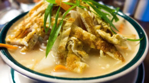
Being a region with the descendants from Tibet most of the people consumes Thukpa is another traditional dish common among “Monpa” a tribe of Arunachal. However on every corner, one can see a lot of Momo stalls on their way for trekking in the state of Arunachal Pradesh.
Why Arunachal Pradesh?
Being a region with few high mountains, it has a magnificent view of the hills. Some of the main important cities like Tawang, which is an important center for Buddhist monastery prayer center. Situated near the border of Bhutan and China and it was also visited by Dalai Lama once upon a time it has been attracted by many foreign tourists around the globe to visit here once.
Bomdila, situated near the town of Tawang has a population of less than 10,000 people living it it. Here, Visiting the local markets and the Bomdila (GRL) monastery are the top things to do in Bomdila.
How to reach there?
As stated above, going to the regions in the north-east side of India requires a special pass, and that one can avail in the cities of Guwahati, Kolkata and New Delhi. However, going to Arunachal Pradesh one can only go by road. in which National Highway 52-A connects Itanagar to Assam and other parts of the country. Regular bus service is available from Guwahati to Itanagar
By rail, there is only one railway station present in the state, name Naharlagun Railway Station which is 20 km away from the capital of Arunachal Pradesh.

Assam
The second largest state in the region, is a home to one of the famous national park in India named “Kaziranga National Park”. It homes to the famous Asian One Horned Rhinoes. Declared as a World Heritage site by the UNESCO organisation, it also homes to many other wild animals that is the Elephants, the water buffaloes and the Swamp Deer. It also homes to variants of birds, flowers of varient species.
What to see in Assam?
Being a home to the Kaziranga National Park, one can visit the Manas National Park too. However, here we are to say a few best places to visit to make your Assam journey a memorable one.
Kaziranga National Park – This is the only place in the world which is a home of One-Horned Rhinoes, and one must visit to see this species that you normally only find in the zoo. Take the opportunity to touch their rough folded skin. The best time to visit is from November to April when it is cool and dry and easy to spot a rhino lying under the winter sun across the burnt grasslands.

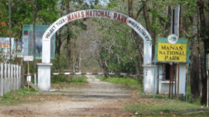
Manas National Park – Is a national park, UNESCO Natural World Heritage site, a Project Tiger reserve, an elephant reserve and a biosphere reserve in Assam, India. Located in the Himalayan foothills, it is contiguous with the Royal Manas National Park in Bhutan. The park is known for its rare and endangered endemic wildlife such as the Assam roofed turtle, hispid hare, golden langur and pygmy hog. Manas is famous for its population of the wild water buffalo.
Lush Of The Tea Garden – Indians are addicted to drinking tea, so if you are addicted in drinking tea and that not visiting the tea garden is like making a big mistake in your life because Assam tea is one of the best tea varieties in the world. So take a step in visiting the lush green fields of the tea estate after visiting the Kaziranga National Park and take a walk along the shrubs of the tea estate, while you can have a watch of the tea pluckers in action plucking up the tea leaves.

Spirituality of the Kamakhya Temple – It is one of the oldest of the 51 Shakti Pithas. Situated on the Nilachal Hill in western part of Guwahati city in Assam, India, it is the main temple in a complex of individual temples dedicated to the ten Mahavidyas, Kali, Tara, Sodashi, Bhubaneshwari, Bhairavi, Chhinnamasta, & Dhumavati. This beautiful Temple is perched high up on a hill and is dated back to the 9th century. The journey up to the temple itself is breathtaking, and once you’re on top of the hill, you can see the entire city below across the fleeting clouds.

Majuli Island – The largest river Island in the world,, Majuli is one great spot for you to feel as if you are standing on an island on the path of the river Brahmaputra. The people on this idyllic island, who are called ‘Misings,’ are really warm and friendly and would help you in any case of trouble. So make an unforgettable experience of sitting on the island bank facing the Brahmaputra with the abundance of greenery behind you.
How to go there?
With the three modes of going there, we would tell you the best way to arrive at Guwahati.
By Air – The state comprises of only one International Airport, named as Lokpriya Gopinath Bordoloi International Airport situated in Guwahati. It is well connected to other metropolitan cities.
By Rail- A well connected rail connection is done with the city, Guwahati Railway Station and Kamakhya Junction railway station. Regular trains from Kolkata, New Delhi, Mumbai, Bangalore, Chennai and Trivandrum would be available.
By Road – The state of Assam is the second stop after Sikkim which is connected only through one passage known as the Siliguri Corridor.
Manipur – The Jewel of India
Bordered by Nagaland in the north, Mizoram in the south towards the east we meet the international border of Myanmar and on the west is the state of Assam this far east state of Manipur is often recognized as the jewel of the area. The capital being Imphal, the state has mainly being focused in the field of Agriculture as the main occupation. Thus, we have seen a lot of farmers who have been working in the hilly fields farming green leafy vegetables like tamarind, garlic, etc.
Things to see in Manipur
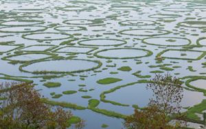
Loktak Lake – The largest lake in the north-east region, it is the only lake in the world having floating islands on the lake. Also known as a floating lake it is a main source of providing fresh water to the nearby regions. Considering the ecological status and its biodiversity values, the lake was initially designated as a wetland of international importance under the Ramsar Convention on 23 March 1990.
Andro – A village situated in the east side of the capital of Manipur, Imphal is the confluence of scenic beauty, lovely climate and warm hospitality. It is known for the way its beauty has been preserved by the locals. The Loi communities are known for their indigenous liquor. The mainstay of Andro is agriculture and is what the entire village survives on. The park in Andro is known for its natural beauty of the neighbouring gardens. It is also known for its historical facts. An orchid farm is also being developed to attract more tourists to this area. The Mutua Cultural Heritage Complex that showcases major tribal traditions and their artefacts is a popular tourist attraction.

Khongjom War Memorial – The British have often fought a war in the north east region of India during the reign of the Manipur Kingdom and in the battle of Khongjom or in the Anglo-Indian War which lasted for nearly one month has lead to the victory of the British rulers.
On this occasion, a war memorial was built in the Honour of Major General Paona Brajabashi for his valour against the invasion of the British Army. It has been constructed on the top of Kheba hill and Khongjom day is celebrated every year on 23rd April.
How to go there?
By Air – Flights to Imphal International Airport is well connected from various parts of the country. Daily flights are being served to New Delhi, Kolkata, Silchar, Guwahati, Bagdogra and Mumbai especially from Indigo Aviation.
By Road – Manipur is connected to all its neighbour states with National Highways to Guwahati, Aizwal, Kolkata, Agartala, etc.
Manipur state does not have any rail services for time being, however the rail services are being constructed and would be available to the public by the year 2019.
Meghalaya – Abode of the clouds
Bordering in the middle of the state Assam in the north and the country Bangladesh in the south, Meghalaya is known as the Scotland of India. The state of Meghalaya is mountainous, with stretches of valley and highland plateaus, and it is geologically rich. This state recieves a lot of rainfall throughout the year with an average annual rainfall as high as 12,000 mm (470 in) in some areas, Meghalaya is the wettest place on earth, especially the city of Cherrapunji.
Things to see in Meghalaya
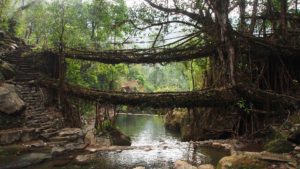
The Living Root Bridges – are a form of tree shaping common in the southern part of the Northeast Indian state of Meghalaya. They are handmade from the aerial roots of Rubber Fig Trees (Ficus elastica) by the Khasi and Jaintia. With nature’s beauty, one can only think as to what she can do to make it durable in the coming years.
Jaintia Hills – Take a visit to the Jaintia hills who are known for the rich mineral deposits and extreme natural beauty. Jowai, Nartian durga Temple, Khim Moo Sniang, Thadlaskein and Umang Lake, Kiang Nongbah Monument, etc are some of the tourist attractions around the Jaintia Hills.
Nohkalikai Falls – After the Jaintia Hills visit, take a drive to the wettest place on earth, Cherrapunji. Where you can visit the Nohkalikai Falls whose height is at about 340 meters above. The reason as to why this falls is to be visited is that below the falls there has formed a plunge pool with unusual green colored water. So take a bathe on the pool and make a fun memory with your family.

How to reach there?
Shillong being the capital of the state is located at the Khasi hills of the state. Due to this transportation to this region was difficult for engineers to find a proper direct way of transportation.
By Road – Reaching the capital by roadways are the best and primitive method used by people of that region. It is well connected by roads with all major northeastern states. Two major National Highways pass through:
- National Highway 40 (India) – Connected to Guwahati
- National Highway 44 (India) – Connected to Tripura & Mizoram (NH 44A)
By Airways – The airways are connected quite poorly to this place. Being at a height of 887 metres above mean seal level flights landing at this airport has found difficulty in reaching here. Only flights to Kolkata and Agartala has been made available on a daily basis.
Otherwise the next best alternative is to go to Guwahati airport and book a cab to reach Shillong in the next three hours.
By Rail – Railway connection has not been made in the state, where one can visit here only by road that by arriving at Guwahati railway station and taking a reserve car to Shillong.
Mizoram
Snug in the lap of emerald green forests that club up with bamboo groves, vibrant wildlife, sheer cliffs and sparkling waterfalls, Mizoram is a unique mix of old folklores and villages built on stilts, a land where an enormous amount of morning mist unfolds throughout the hills and peaks.
What to see in Mizoram?
Champai – Champai has the biggest stretch of plains in Mizoram which is used for rice cultivation and nights here showcases millions of stars twinkling in the sky. A trip to Ruantlang is a must do.
Rihdil Lake – The legendary lake is believed to have been the inevitable passage that spirits of the dead crossed on their way to their future abode known as Mitthi Khua.
Tamdil Lake – Visit the Tamdil lake which is developed as an important pisciculture centre by the Fisheries Department and a holiday resort by the Tourism Department. Also don’t miss out the fish seed farm.
Vantawng Falls – take a drive to Vantawng waterfall and the magnificent waterfall of Tuirihiau. Stay over at Hmuifang Mountains.
Reiek Mountians – A tourist spot about 29 km from the city of Aizwal, this is a perfect place to go for a mountain hiking or for trekking and lose yourself with the breathtaking views of the surrounding hills.
How to go there?
To reach Mizoram, one can go by air and by road as rail route to this state is not open and is under construction.
By Air – the Lengpui Airport situated at the capital of the state is the only airport being well connected to New Delhi, Mumbai, Kolkata and Guwahati. It is advisable to go with Jet Airways who provides daily services from these regions.
By Road – With the surface connection in Mizoram, it is well connected to Guwahati, Aizwal and the other seven sister states through the national highway of the country.
Nagaland
Located in the far east with Manipur at its border in the south, Assam in the west and Burma in the east, Nagaland is truly a home to natural biodiversity. With 16 tribes inhabiting the state Nagaland is a place which is rich in diversification of the tribes and that visiting here is an important stop to the region.
This state is mostly mountainous except those areas bordering Assam valley which comprises 9% of the total area of the state. Mount Saramati is the highest peak at 3,840 metres. Agriculture has been the main occupation of the place with rice, corn, millets, pulses, tobacco, oilseeds, sugarcane, potatoes, and fibres being the main product.
What to see In Nagaland?
Going to Nagaland is like an experience which you have always seen it on TV. One such thing is that the region being predominantly a hilly place where you can experience a dirt bike challenge off the cliff of the hills.
Nagaland is a place where India meets bhutan just like other states too, however this is a land of rugged hills and tribes where ancient headhunting habits have collided in a train wreck against the Burmese identity, leaving modernity derailed .
This rugged borderland is home to the Konyak people, an ethnically Tibeto-Burmese group that has expanded into India from the adjacent Mon state of Myanmar.
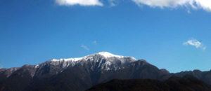
Mount Saramati – The highest point of the state, Mount Saramati is not so high with an elevation of 3,841 metres above mean sea level. The mountain range is groomed with rich natural and diverse forests, visible at various altitudes, ranging from sub-tropical ever green and semi ever green to temperate broad leaved and Alpine vegetation. It has good bio-diversity with natural flora and fauna and various kinds of orchids.
Once at the peak of the mountain one can have a nice view of the Myanmar forest, belonging to the Makury Naga, Chindwin river etc. Saramati can be reached in two days from Pungro via Thanamir or Khongjiri village, both villages are of visual natural delights with hospitable villagers.
Kohima War Cemetery – This is a memorial dedicated to soldiers of the 2nd British Division of the Allied Forces who died in the Second World War at Kohima, the capital of Nagaland, India, in April 1944. With 1420 ceremonial burials and along with the crematory of Hindus and Sikh soldier with respect to their faith. One must visit this site for a view one.

Dzukou Valley – This place has a stunning view of the flower valley will definitely blow your minds away. With a 520 species of flowers being grown here, it makes you feels as if you are standing in Paradise. Multicoloured flowers, such as the Himalayan Marsh Orchid, Brahama Kamal, Jacquemont’s Cobra Lily, Elegant Slipper Orchid, Yellow Cobra Lily, poppies, marigold, rhododendron, primulas, daisies and more, can be seen here. Take a day trip here to see the paradise that has been unexplored by the mass of the commons.

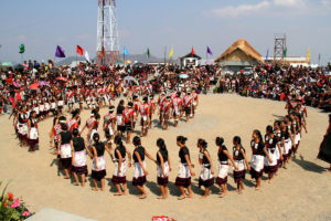
Nagaland is a land of Festivals and the diversity of people and tribes, each with their own culture and heritage, creates a year-long atmosphere of celebrations. In addition, the state celebrates all the Christian festivities. Traditional tribe-related festivals revolve round agriculture, as a vast majority of the population of Nagaland is directly dependent on agriculture. Some of the significant festivals for each major tribe are Sekrenyi celebrated by Angami, then we have the Moatsu, Tsungremong celebrated by Ao, Tsukhenyie, Sekrenyi celebrated by Chakhesang, etc.
How to go there?
By Road – The capital of the state Kohima is well connected to the country by the national highways 61, 29, 36, 150 and 155. Most of the highways are well linked to the financial capital of the region, Guwahati.
By Air – Dimapur airport, about 70 kms away from the capital is the only airport that serves the people of that region to the nearby metropolitan cities of Kolkata, New Delhi, Guwahati, Bagdogra and Mumbai. Best flight service to take would be Indigo Aviation
Sikkim – Land of the Thunderbolt
Joined India in the year 1975 and choosing over India’s democracy instead of China’s this state plays a vital role for the protection of the other states in the North east of India. It is a home to one of the highest peak in the world, the Mount Kanchenjunga and is also having one of the biggest national park in the Himalayan region named as the Kanchenjunga National Park. Due to this this place is as beautiful as the valleys in the Kullu or Shimla.
Where to go?
Gurudongmar Lake – Up on the northern part of the state, the lake is one of the highest situated lake in the world. It is fresh water lake and that the neighbouring villages have this as the only source of water of living and irrigation facility. This lake has one thing different is that in all the four corners of the lake only one side of the lake does not freezes through out the year, irrespective of the season even being winter.

Take a walk along the banks of the lake and enjoy the cold, chilled natural winds blowing from the north and the snow found in the nearby regions.
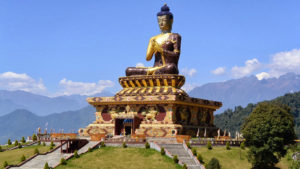
Ravangla – Home to at least 5,000 people in this village, one can take a view of the mountain of Kanchenjunga behind the statue of Buddha at the Buddha park. Take your time to dwell deep into your mind to avail peace in your body in the park and enjoy every moment of the scene.
Namchi – Capital of the South Sikkim district, Namchi is an important stop for tourism and financial center apart from Gangtok. The statue of Guru Padmasambhav and the Chargham. See the wonders of the beauty of the various kinds of Hindu temples of both north and south Indian temple culture and architecture.

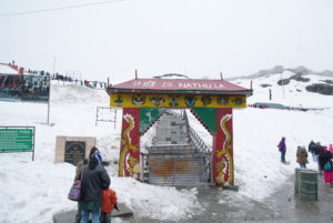
Nathu La Pass – This is the region where the Indian border meets up with the Chinese border and has been long history on it’s name. This pass is extremely important as it leads to the capital city of Tibet. Travellers from all over India take their time to visit this place to take an experience of how proud one can be of it’s country.
How to go there?
By Road – Sikkim is well connected by road. The National Highway number 31-A is well connected to the state capital Gangtok to other part of the city from Siliguri-Sevoke Highway road. The Coronation bridge is the by-pass which divides the highway one to Assam and the other to Sikkim.

By Air – The closest airport to the region is the Bagdogra Airport which is 9 km from the city of Siliguri and 80 kms away from Gangtok. Daily flight services are provided to civilians to Kolkata, New Delhi, Mumbai, Guwahati, Bangalore.
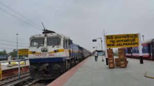
By Rail – Being completely in the Himalayan belt, it does not have any railway station. The nearest railway station one can board a train back home is New Jalpaiguri railway station at the outskirts of the town of Siliguri. Trains are well connected to New Delhi and Kolkata as well as to Mumbai, Chennai, Bangalore, Trivandrum.